Showing posts with label sayulita. Show all posts

Monday, May 28, 2018

Exploring Little-Known Petroglyphs Off the Beaten Path in Nayarit, Mexico

"On this long volcanic rock, they would lay down the person selected for sacrifice. She would extend her legs toward the temple, and hold her head back here where the rock dips down. That's when they would cut her throat.  Take off the entire head."  The Huichol shaman was telling us about the past. We were an hour and a half from Puerto Vallarta, an hour from formerly sleepy surfer town of Sayulita, but we might as well have been on another planet. 


A breeze rattled the dry leaves along the dry creekbed in this isolated corner of the coastal state of Nayarit, Mexico. It sounded like rain. That's exactly what the gods who controlled the rains wanted. They wanted the blood to turn that sound, that suggestion of rain, into a reality.

I wondered if this was true and how they knew. I also wondered why there were so many "decapitator gods" in the Americas.  What was described reminded me of the Moche civilization of Peru.


If you were a part of the ceremony, how did you go from a calm quotidian existence to being  a part of a decapitation ceremony?  Just how much pulque, peyote, or whatever else they used would you have to imbibe?

In my mind thumped the joyous hooks and beats of the Swedish artist known as Avicii, of "Levels" and many others, and I could certainly understand the mass energy and euphoria of crowds.

Was the spraying of the victim's blood a cause for euphoric ululations? Of a faster pace of dancing and euphoric drumming and piping?  Or, was the ceremony dark and horror-tinged?

I shivered.  How did we get here in this unknown tributary flowing into the Pacific Ocean in a part of Mexico where Canadian and American tourists flocked to be a part of a so-far safe stretch of coastline, quickly converting itself into a tourist bubble?

Near Las Varas, where the new highway will shave an hour off the journey from Guadalajara, along with the dangerous curves and mountain passes of the Sierra Madre del Occidente, is the little mountain village of Alta Vista (high view), which lies around 10 km from the two-lane highway that takes people from La Peñita to Las Varas.

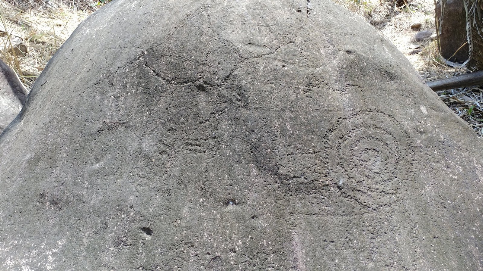
And, tucked away along the banks of a rocky little stream, and a more or less dry riverbed (in the dry season) are petroglyphs - carvings from the Huichol Indians, or from their preHispanic forebears.  Or, based on the way they have eroded in the last 10 years, it's possible that they were carved by some industrious stoneworkers who thought it might be a great way to attract government support.  I am not an expert, but Miguel did say that they look a lot more faint than they did just 10 years ago. Were they worn away by visits from tourists?  Have they become so popular with the shaman "soi-disant" the self-styled but well-meaning purveyor of emotional, psychological, and for the really self-actualizing (or at perhaps absolutely shameless), physical healing.


We tried Google Maps. It showed the town and a ceremonial center and museum. We went there. Nothing.

We tried Googling Alta Vista petroglyphs. There were many blog posts, Wordpress postings, websites that featured photos of the petroglyphs, and many with a blow-by-blow description of the hike. But, there were no maps and no details about how to actually find the petroglyphs except to assure the reader that there was absolutely no way to find the petroglyphs without the services of a guide.

We were not convinced. We went down one little cowpath and dirt road after another. No luck.

Finally, we asked someone in the town of Alta Vista how to find the petroglyphs. They said to go back down to the place where the road split into two directions and to inquire at the snack stand located there. It's weird to describe it this way, but that's the only way I know how to describe the little commercial center at the fork in the road.  It was an impromptu food stand that sold the kind of food people love to buy on the street -- tacos al pastor and such -- with the basics of water, soft drinks, etc.


We asked directions and immediately a young man offered to be a guide for 80 pesos, which was about 5 dollars -- and for all day.  I thought it was a sad commentary on income inequality - a young man was willing to work all day for 5 dollars (but in reality it only took 2 hours) when a toll road that took 30 minute to cross cost 200 pesos (around 11 dollars).  There is something wrong with that. But, I am not really in a position to comment about that.

We drove down the same highway we had gone down before, and just across the road from a field with a herd of "vacas flacas" (skinny cows), there was a small path with a gate fashioned of wood and barbed wire. Christopher hopped out and opened the gate.  It was not locked and presumably open to the public but there were no signs at all and presumably the public would need to know about this. Plus, the public would need to know that there were no cartels, drug trafficking or other kinds of trafficking to happen upon. It would not be good to stumble upon marijuana or opium poppy cultivation. Presumably Christopher would only take us places where he (and his clients) would be safe.

We headed down the path. To our left was a large guanábana orchard. Christopher entered and plucked a rather large and still quite green guanábana. "It will be ripe and ready to eat in 3 or 4 days," he said.

We drove farther down the path, past a mango orchard. We parked under a large, spreading mango tree (un mangal). We found ourselves at another fence, this time without a gate. Christopher lifted the wires so we could enter, and we did so without any problem at all.

Once past the wire, there was a small path into a clearing. This was the so-called "Ceremonial Center" of the "Pilar del Rey." There were hand-painted signs with neat lettering - white paint on black metal, in Spanish and then in English. The signs explained the function of the petroglyphs, the presence of a ceremonial center, and the culture of the people who lived here, who were antecedents of the Huichol.  The clearing was rather large, and so I supposed it must be a favorite location for small events or gatherings, although it was hard to imagine that it would be very easy to access.

The signs led us toward a creek bed where there were more signs and large rocks. The first sign described the meaning of the carvings, which were the petroglyphs. It indicated that the glyphs referred to the sun, the moon, directions, some sort of god figure, and human sacrifice.  It seemed highly interpretive to me.  We made our way through the leafy underbrush and I was quite glad we were in the dry season. It was warm, but not hot, and while it was a bit humid, it was very bearable.  I imagined that it would be more or less pure torture during the rainy season.  The leaves slapped my legs, but fortunately they were not thorny or wet. I was wearing khaki colored capris and they stayed unblemished.


We passed by more petroglyphs, some indicating the god of corn, others indicating a cross. The theory was that somehow some sort of Christian saint had visited before the arrival of Spaniards.

"Ockham's Razor," I thought to myself.  I could think of at least five more likely explanations for the appearance of what seemed to be a Cross of Malta on the rocks (and for the petroglyphs themselves).  It seemed much more likely to have carvings by Spaniards and settlers, even if simply to amuse themselves. But, I'm no anthropologist.

The rocks they claimed were part of a pyramid looked like the normal joints you'd see in volcanic rocks, but again, if you asked me what the mounds near Saint Louis were or what the hillocks were in Chiapas and the Yucatán, chances are, I would have attributed all to geological and geomorphological processes.


We arrived at a small pool fed by springs where a clutch of gaudily tattooed Mexicans and Canadians were smoking marijuana and stretched out on the rocks. On a ledge where people offered "ofrendas" (feathers, stacked rocks, yarn "eye of god" crafts, a dreamcatcher or two) a young man wearing a Huichol priest outfit with gorgeous embroidery was talking about the spiritual beliefs of the Huichol. He said that he often participated in dances in Sayulita and wore a deer skull. I asked if the Huichol believed in the animal spirits and visions of animal spirit guides. He said, "yes."


I thought of the Navajo sand painters who combined the painting with spiritual healing and thought he could go far if he combined some of the petroglyph shapes here with a kind of sand painting ceremony for healing.

I did not share my idea, though.  I had already asked him too many questions and I think I seemed a bit weird.

We made our way back and I laid out some coins that amounted to probably $1.50 at best. My ofrenda looked nice and shiny on the rock, and it was nice to think that it was Earth Day as well.

As we made our way back through the creek bed, past the ceremonial area and then squeezed through the barbed wire and opened up the car, I took a long drink of bottled water and reflected on the experience.

There was no doubt that it was totally inaccessible to someone who did not know precisely where it was. GoogleMaps had the ceremonial center far to the north of the town of Alta Vista.

The road to Alta Vista continued up into the mountains where they grew coffee that was supposedly some of the best in Mexico. I wondered if there were also poppies, as a bit farther along the coast in Sinaloa or Guerrero.

What would your garden grow?  I'd rather have a crop of petroglyphs.


Saturday, December 05, 2015

Interview with Pat Wagner, Facts about Owning Property, Doing Business in Mexico


Visiting, studying, living, and establishing partnerships and great working relationships in Mexico is both a dream and a reality for many people. But, how do you get started? What are some of the recent changes that have taken place?

Welcome to an interview with Pat Wagner, who moved to Sayulita, Mexico (a brand new "Pueblo Mágico) more than 20 years ago, and who has been working as a realtor there since 1991. She describes Sayulita, her experiences in Mexico, and some of the recent changes which make it easier for foreign nationals to buy real estate property and to do business in Mexico.

1.  When did you move to Sayulita, Mexico and how did you choose Sayulita over other places?
We first visited Puerto Vallarta in 1982.  We eventually decided to to purchase a house in Bucerías through the original owner of this office. We had traveled via motor home through Mexico and decided on this area due to the international airport.  We were between Puerto Escondido and Puerto Vallarta area. Sayulita really wasn't a destination at that time. Bucerías was considered out in the boonies. Sayulita started to become slowly popular in the early 90s.  I was offered a full time position in 1991.
Sayulita, Nayarit, Mexico -- new Pueblo Mágico
Sayulita, Nayarit, Mexico: New Pueblo Mágico

2. Where exactly is Sayulita?  What is it known for?
Sayulita is on Latitude 22 * (coincidentally, there is a local restaurant which was named for location). It is located approximately 40-45 minutes north of the Puerto Vallarta airport.  It is 2 hrs by plane from Los Angeles, 2 hours from Dallas. With a layover, it takes about 5 hours to arrive here from the east coast of the U.S.  Sayulita was known for being a fishing and surfing town. Now it is a hippish town. I  sometimes say people are looking for Timothy Leary, but we don't tell them that he has died.

3. What makes Sayulita so desirable for foreigners as well as citizens of Mexico?
 When Cabo had the hurricane and earthquake recently guests, both Mexican nationals and foreigners had the option of going to Cancun or coming here. Once here, we spoke with several people who said they never realized Sayulita existed. The Mexican nationals said they would definitely return. Here are a few things they like:  The laidback attitude. The fact that friends and family are very important. Business can always be dealt with. Long drives are unnecessary here.


View of the Pacific Ocean - Sayulita, Nayarit

4.  What are some of the things that have changed to make it easier for foreigners to own property in Mexico?

susan smith nash, ph.d., dante ferrari, pat wagner - LifeEdge #24
Interview with Pat Wagner on YouTube (LifeEdge #24)
The Mexican government decided in 2000 to start to eliminate the ejidos and make all properties have a title. Once the title is issued the foreigner then may apply for a Bank Trust. Prior to that, the properties were held in name lenders (prestonombres or Mexican nationals for ejido which was illegal according the Mexican constitution. Yet many notaries would transfer possession saying it was an interpretation of the law.) So, things are much improved now.

5.  Please describe the way that people stay in Sayulita -- boutique hotels? their own home? renting a home or apartment? youth hostels? air BNB?

Accommodations have evolved from very rustic camping, parking on the beach, renting rooms in villagers' homes to what we currently have, which include hostels, BNB's, boutique hotels, renting either a private home or apartment, or staying in the luxurious rooms at the Four Seasons in nearby Punta Mita.
 
6.  What are a few tips that make living and doing business in Mexico successful?

Living in Mexico is a reality call. We were stepping into another time zone when we came in the early 90's. It honestly felt like the late 1800's. Children used their toys in the dirt and made bridges, race tracks whatever their mind designed. When we came there was just one phone in the entire town. You called the phone and young child would run to your house and tell you to come to the phone store for a call. Today everyone has cell phones. So we are stepping into the current world.


Most people maybe self business owners have to follow the following. The Mexican government has a rule that there must be only 1 foreigner to 10 Mexican employees.  That is for a foreign owner. To work you need to have working papers where the business sponsors you to work. 

The best advice is expect nothing and change nothing. Go with the flow and just relax and enjoy the beauty around you.


Wednesday, June 17, 2015

Hed Kandi Sayulita Beach House: Travel-Tourism Economic Development Using Social Media

I love Hed Kandi’s chill and house mixes and eagerly look for them. They evoke a beach and surf vibe and even if I’m squeezed into an economy seat on a sold-out regional jet flight, I am immediately transported to gorgeous places and climates. 

For example, I imagine Sayulita, a bohemian coastal village in the Nayarit Riviera in Mexico close to Puerta Vallarta, famed for its surf and Stand Up Paddle Board (SUP)  competition in May.

In certain times of the year, Sayulita is a mellow place of pink sunsets and glassy waters.

sayulita, nayarit - susan smith nash, ph.d.

However, according to blog posts and reviews, Sayulita was pure enchantment 30 years ago, but has been sullied by crowds and poor infrastructure, as well as a failure to enforce sanitation laws.

This is disappointing to me, and I wonder how many others are like me – they’d love to spend an extended amount of time in a beach community, and perhaps even invest in a house or a business.

Accelerating Private Infrastructure Investment for Economic Development

Perhaps the problem is that of a lack of private investment for infrastructure which is uniformly administered by a board that follows an approved development plan.

sayulita sand tortugas - photo by susan smith nash, ph.d.

Personally, I think it would be a good idea to use templates already in place for development plans. For example, the “Pueblo Mágico” concept in Mexico has resulted in gorgeously maintained villages which are charming and clean. Examples that come to mind in the state of Jalisco are Tapalpa and Tequila.

It would be a good idea to share infrastructure improvements in order to encourage development via social media:
•    tweet new developments
•    post photos of prize winners on Instagram & share
•    use LinkedIn to connect owners of businesses / services
•    post videos of contests & the implementation of new infrastructure on YouTube
•    develop weekly shows to post on YouTube

While it might be tempting to try to shame people into not erecting fences that encroach on public roads, disregarding property lines, leaving piles of mangos and fallen branches to rot, and to letting their dogs run free in the streets and beaches, putting up ugly photos on the web is a very inadvisable strategy that will certainly have unintended negative results. It’s much better to encourage and envision positive change, and reward steps made in the right direction.


Friday, May 08, 2015

Situated Learning in Practice: Integrated Conservation and Development Programs

 Countries and communities that have the good fortune to be near areas of biodiversity and beautiful beaches, mountains, rivers, fields, and forests often cite nature tourism as a key strategy for preserving the integrity of natural resources and alleviating poverty. In doing so, they integrate conservation and development programs, and try to avoid the pitfalls that are often associated with tourism, such as social disruption, the abandonment of cultural heritage in favor of low-wage jobs, the commodification of biodiversity, and social inequality.

Being successful in establishing sustainable Integrated Conservation and Development Programs (ICDPs) requires a clear training and education program which place the education clearly within a framework of practical applications.

Integrated Conservation and Development Programs


The ICDPs can result in economic benefits to the community, but that is often insufficient to guarantee sustainability because of fairly inevitable disruptions to lifestyle, traditional ways of earning a living (farming as opposed to formal employment). Further, satisfaction may plummet because perceived social inequality and restrictions on former lifestyles (SilvaJulie, 2014).

Situated learning is critical in the development and implementation of ICDPs:

     •    Conservation involves preservation of ecosystems
          o    Identify elements of ecosystems
          o    Explain which elements are most vulnerable

     •    Dealing with unexpected consequences: reduced opportunities for agricultural production, restriction of activities at home
         o    Describe the changes to communities and shared resources that require restricted activities (no agricultural expansion, changed practices)
         o    Identify the new types of activities and the skills requirements
         o    Create a plan for developing local talent for jobs with responsibility
         o    Identifying potential areas of social disruption / loss of cultural authenticity

    •    Taking advantage of economic development resources
         o    Create collaborations between locals and renowned experts for developing project plans
         o    Construct systems for administering new programs
         o    Develop lists of available incentives (tax credits, infrastructure projects, corporate promotions)
         o    Identify human resources and the needs to be satisfied

Implementing the situated learning approach requires the following elements:

     •    Collaborations, both face-to-face and with virtual communities of interest (Akoumianakis, 2014)
     •    Wiki or portfolio development of goal-focused information, such as habitat analysis, botanical information, etc.
     •    Repositories of information for marketing/outreach as well as operations (Libord &  Hjalager, 2010)
     •    Enacted social formations (Akoumianakis, 2014); travel communities (Lonely Planet, etc.) and virtual business communities (Travelocity, etc.)
     •    Knowledge management for communities of  interest

Case Study: Sayulita, Nayarit, Mexico

Sayulita, Mexico, which is an economy driven primarily by tourism, is a perfect location for the implementation of an ICDP, which in turn could benefit from the application of situated learning.

Sayulita is a fishing and surfing town on the west coast of Mexico north of Puerto Vallarta in the state of Nayarit. It has been featured in a number of books about world-class surf sites, and has also become a destination point for Canadian and American tourists and retirees. It has a bohemian vibe, and as opposed to Puerto Vallarta or Nuevo Vallarta, Sayulita does not allow large developments.


As a result, the town consists of a small plaza and business area, narrow unpaved streets, steep hillsides with tropical foliage, and clusters of small houses, bungalows, and multi-family rentals. There are two main beaches: a larger one that has a number of docking areas for boats, and a small one that one must access by going through a cemetery, hence the name, Playa de los Muertos. On November 2, el Día de los Muertos, family members leave orange marigolds (cempasúchitles) on the above-ground tombs.

The goal of many property owners in Sayulita is to expand / develop the area, especially as funds pour into the “Nayarit Riviera” in Puerto Vallarta, Nuevo Vallarta, and Punta Mita. The challenge for the property owners in Sayulita is that many of them are small holders, and also may not be full-time residents. Some are retirees and want to try a second career, but have no idea how to get started.

Further, they are very interested in protecting their investments, and a few recent developments have caused many owners to worry. For example, there is insufficient parking in the town, which is exacerbated by the fact that many restaurants place few tables inside. Instead, they put tables on the sidewalks, and even into the street itself, where diners run the risk of being run over by an errant car. They also have to contend with eating a lot of dust, and being menaced by the hordes of mongrel dogs and escaped chickens that roam the streets, adding to both charm and public health concerns.


Another concern is the fact that the few roads that provide access to the beach are very narrow, and often clogged by SUVs parking on the side. Further, the beach on the side of the cemetery, the “Playa de los Muertos” has less parking than ever since three food stands have opened, literally between and in front of the tombs. A charming location runs the risk of becoming a rather crass and potentially unwholesome crush. The recent developments run the risk of degrading the environment as well as the cultural heritage and authenticity.  It also runs the risk of exacerbating social inequality, and stripping the Sayulita original inhabitants of their culture and traditional ways of earning a living (Falk, etal, 2012).

The challenge for the property owners involves the following:

     •    Developing a strategy for preserving the environment
     •    Creating an economic development program
     •    Design a plan that integrates property interests and economic development via nature tourism

In order to be effective, all the activities will require learning programs, all of which should be closely aligned with the strategic goals and mission of the stakeholders.

References

Akoumianakis, D. (2014) Ambient affiliates in virtual cross-organizational tourism alliances: A case study of collaborative new product development.Computers in Human Behavior, Volume 30, January 2014, Pages 773-786

Falk, J. H, Ballantyne, R, Packer, Pierre Benckendorff, P. (2012) Travel and Learning: A Neglected Tourism Research Area.  Annals of Tourism Research, Volume 39, Issue 2, April 2012, Pages 908-927

Libord, J., Hjalager, A. (2010) Changing Approaches Towards Open Education, Innovation and Research in Tourism, Journal of Hospitality and Tourism Management, Volume 17, Issue 1, 2010, Pages 12-20

SilvaJulie A., Lila K. Khatiwada (2014) Transforming Conservation into Cash? Nature Tourism in Southern Africa. Africa Today, Vol. 61, No. 1, Special Issue: Narratives of the African Landscape: Perspectives on Sustainability (Fall 2014), pp. 17-45

Blog Archive